
No final de agosto, o Maple Cutter da Guarda Costeira dos EUA com 60 m de comprimento, completou sua navegação através da passagem Noroeste do Ártico. Embora esta não seja a primeira vez que os navios tomaram esta rota, foi a primeira vez que a International Ice Patrol forneceu informação sobre icebergs com base exclusivamente em imagens de satélite.
Satellites guide ships in icy waters through the Cloud
In late August, the 60 m-long US Coast Guard Cutter Maple completed its navigation through the Arctic’s ice-ridden Northwest Passage. While this was not the first time ships had taken this route, it was the first time that the International Ice Patrol had provided iceberg information based exclusively on satellite imagery.
Established in 1914 in response to the sinking of the Titanic, the US Coast Guard International Ice Patrol (IIP) monitors iceberg danger in the North Atlantic Ocean for shipping safety.
When the Maple departed from Alaska in mid-July en route through the Arctic to Maryland, USA, the IIP was on guard to assist the crew to navigate through the notoriously icy waters.
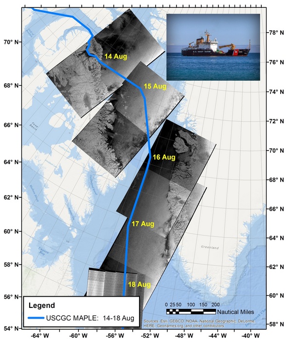
Maple’s course. The region through which the ship Maple transited 14–18 August 2017, with approximate ship locations identified in yellow on each day. The map has been overlaid with images from the Sentinel-1 radar satellite mission.
The IIP used data from the Copernicus Sentinel-1 satellite mission, among others, to create charts showing the risk of encountering icebergs after exiting from the Northwest Passage and during transit through the Baffin Bay, Davis Strait and Labrador Sea.
Sentinel-1 is equipped with radar that can detect icebergs through cloud cover, a capability particularly beneficial in the IIP’s operating area.
Sentinel-1 can also distinguish between the thinner, more navigable first-year ice and the hazardous, much thicker multiyear ice to help assure safe year-round navigation in ice-covered Arctic and sub-Arctic zones.
These radar images are particularly suited to generating high-resolution ice charts, monitoring icebergs and forecasting ice conditions.
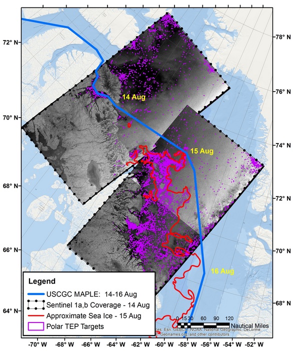
Navigating with Polar TEP. Using ESA’s online Polar Thematic Exploitation Platform (Polar TEP), the International Ice Patrol accessed satellite data to detect icebergs and analyse their densities and trajectories.
Scientists at the IIP used iceberg detection software available on ESA’s online Polar Thematic Exploitation Platform (Polar TEP) to access satellite data to detect icebergs and analyse their densities and trajectories.
“This experience using the Polar TEP cloud-based technology opens the door for future evaluations of a more robust version of the iceberg detection and iceberg trajectory processors,” said Michael Hicks, Chief Scientist of the International Ice Patrol.
“Cloud-based technology such as that used by Polar TEP is expected to be an important tool for handling the ever-growing amount of data coming from space.”
Polar TEP is one of six Thematic Exploitation Platforms developed by ESA to serve data user communities. These cloud-based platforms provide an online environment to access information, processing tools and computing resources for collaboration. TEPs allow knowledge to be extracted from large environmental datasets produced through Europe’s Copernicus programme and other Earth observation satellites. Source: ESA


